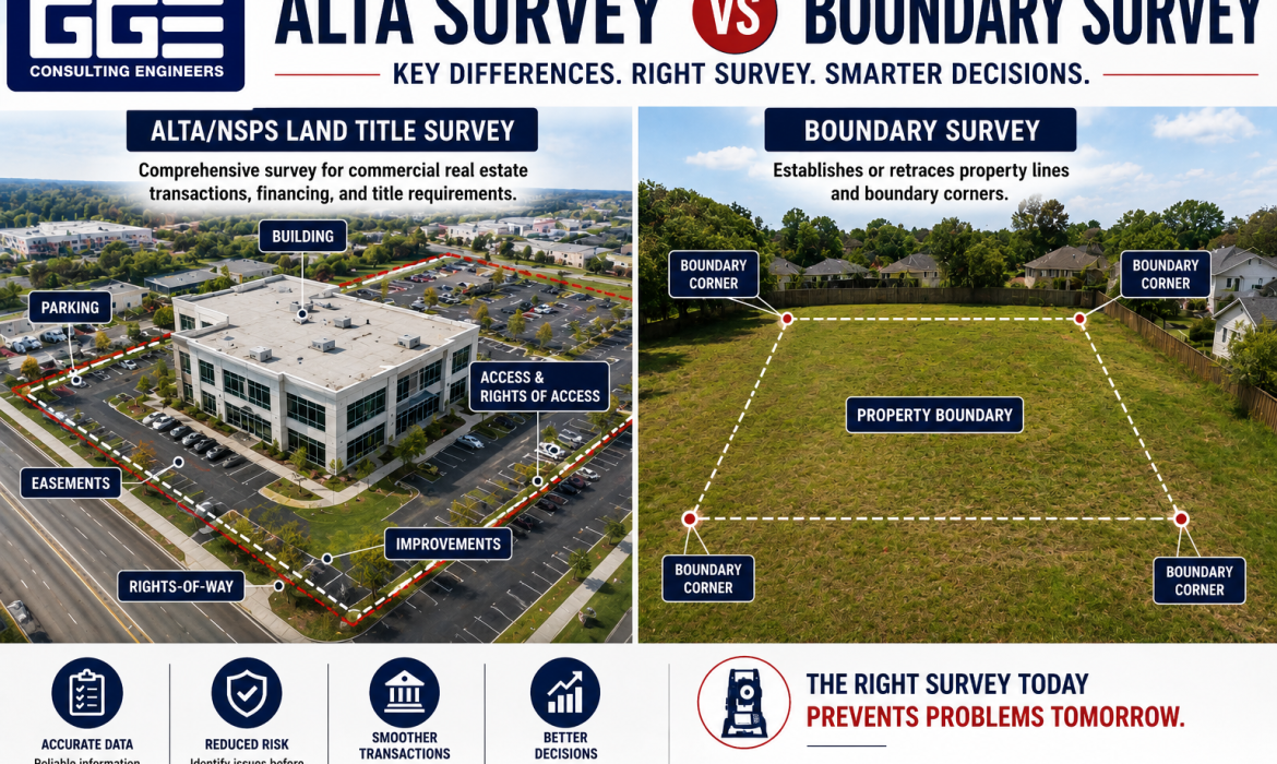
Choosing between an ALTA survey vs boundary survey can be confusing when you are buying, refinancing, developing, or transferring property. Both surveys provide important information about land, but they serve different purposes. A boundary survey primarily establishes property lines, while an ALTA/NSPS Land Title Survey provides broader information for commercial real estate transactions.
GGE Consulting Engineers provides surveying services that can support property owners, developers, and commercial projects in Texas. Understanding the difference between these survey types can help you request the right scope, avoid unnecessary work, and ensure the survey provides the information your project actually needs.
What Is the Difference Between an ALTA Survey and a Boundary Survey?
The simplest way to understand the ALTA survey vs boundary survey distinction is to consider the primary question each one answers.
A boundary survey answers: Where are the legal boundaries of this property?
An ALTA/NSPS Land Title Survey answers a broader question: What are the property’s boundaries, improvements, access conditions, easements, and other title-related physical matters that need to be documented for a commercial transaction?
A boundary survey focuses on establishing or retracing property lines based on legal records and field evidence. An ALTA/NSPS survey incorporates boundary information into a more comprehensive survey prepared according to nationally recognized standards.
The two surveys may overlap in certain information, but their intended uses and scopes are different.
ALTA Survey vs Boundary Survey at a Glance
|
Feature |
Boundary Survey |
ALTA/NSPS Land Title Survey |
|
Main purpose |
Establish or retrace property boundaries |
Provide comprehensive survey information for commercial real estate |
|
Property lines |
Yes |
Yes |
|
Boundary monuments |
Located or established as required by scope |
Included as applicable to the ALTA/NSPS requirements |
|
Easements |
May identify relevant easements |
More comprehensive title-related documentation |
|
Improvements |
May be included depending on scope |
Detailed improvement location is a core component |
|
Rights-of-way |
May be identified |
Addressed as applicable to the survey and title documents |
|
Access |
Limited to agreed scope |
Addresses access and rights of access |
|
Title requirements |
Generally not designed specifically for title underwriting |
Designed to meet ALTA/NSPS standards |
|
Typical use |
Property transactions, planning, boundary matters |
Commercial purchases, financing, refinancing, development |
|
Standard |
Texas surveying requirements and agreed scope |
ALTA/NSPS Minimum Standard Detail Requirements |
|
Typical complexity |
Lower to moderate |
Higher and more comprehensive |
The table shows why simply asking for “a survey” may not be enough. The survey should be matched to the actual purpose of the project.
What Is a Boundary Survey?
A boundary survey establishes or retraces the legal limits of a parcel using legal descriptions, deeds, recorded plats, monuments, field evidence, and other relevant records.
A professional surveyor does more than measure the visible edges of a property. The work involves comparing historical and current records with evidence found in the field. Depending on the circumstances, the survey may also identify encroachments, easements, rights-of-way, and other relevant features within the agreed scope.
A property line survey is commonly requested when an owner or buyer needs to understand where the legal property boundaries fall. It can be useful before purchasing land, planning construction, locating improvements, addressing a boundary concern, or preparing for a development project.
For example, if a property owner plans to construct a new building near a side property line, relying on a fence or an online parcel map may not be sufficient. A professional survey can provide a more reliable basis for understanding the boundary.
When Do You Need a Boundary Survey?
A boundary survey may be appropriate when:
- You are buying or selling property and need boundary information.
- You are planning construction close to a property line.
- You are investigating a potential encroachment.
- You need to verify property corners or dimensions.
- You are preparing for subdivision or site development.
- You need boundary information for a property dispute or legal matter.
The exact scope should be established with a Texas-licensed professional land surveyor because not every boundary survey includes the same additional features or deliverables.
What Is an ALTA/NSPS Land Title Survey?
An ALTA/NSPS Land Title Survey is a more comprehensive survey commonly used for commercial real estate transactions. It follows the Minimum Standard Detail Requirements established by the American Land Title Association and the National Society of Professional Surveyors.
An ALTA/NSPS survey generally incorporates boundary information while also addressing improvements, easements, rights-of-way, access, and other matters required by the applicable standards and requested Table A items.
This is one reason an ALTA survey vs boundary survey comparison matters for commercial property. A standard boundary survey may establish the property’s limits, but it may not provide all the information a lender or title company expects for a commercial transaction.
When Do You Need an ALTA/NSPS Survey?
An ALTA/NSPS survey may be appropriate when a commercial property is being purchased, refinanced, developed, or used as collateral for financing.
The lender or title company may specify the required survey and additional Table A items. Therefore, it is important to obtain those requirements before the surveyor begins fieldwork.
An ALTA/NSPS survey can be especially useful when a property has a complicated title history, multiple easements, numerous improvements, shared access arrangements, or other conditions that need to be documented carefully.
For example, consider a commercial tract containing a building, parking areas, access drives, utility easements, and several recorded easements. A basic boundary survey may establish the parcel limits, but the transaction may require a much more comprehensive review of the property’s physical and title-related conditions.
Property Line Survey vs ALTA/NSPS Survey
A property line survey and an ALTA/NSPS survey should not be viewed as competing versions of exactly the same service.
The primary objective of a property line survey is to establish or retrace the property’s legal boundaries. It is particularly useful when the main question concerns the location of property lines, corners, or potential encroachments.
An ALTA/NSPS survey includes boundary information but is designed for a broader commercial real estate purpose. It can document improvements, easements, rights-of-way, access, and other information relevant to title and financing.
The right choice therefore depends on what you need the survey to accomplish. If the primary concern is where the property ends, a boundary survey may be appropriate. If a commercial lender or title company requires a standardized survey for a transaction, an ALTA/NSPS survey may be necessary.
Why Does the Surveyor’s Role Matter?
Surveying involves both technical measurement and interpretation of legal property records. That is why choosing the right professional is important.
A qualified land boundary surveyor reviews available records, researches the property’s history, examines field evidence, and applies professional surveying principles to establish or retrace boundaries.
The surveyor may need to compare deeds, recorded plats, adjacent property information, existing monuments, prior surveys, and physical evidence. Differences between records and field conditions can require professional evaluation rather than simply selecting the measurement that appears most convenient.
In Texas, boundary surveys and other professional land surveying services are subject to state licensing requirements. It states that land surveying services are performed through Texas Registered Professional Land Surveyor oversight, and the firm identifies Saul Castillo, RPLS, RLS, as its Director of Survey Services.
What Does a Land Boundary Surveyor Look For?
The work performed by a land boundary surveyor can vary depending on the property’s legal history and the scope of the assignment. However, the process commonly involves research, field measurements, record comparison, drafting, and professional review.
Important information can include:
- Deeds and legal descriptions
- Recorded subdivision plats
- Existing survey records
- Property corner monuments
- Evidence of occupation
- Easements and rights-of-way
- Potential encroachments
- Adjacent property information
- Relevant physical improvements
The surveyor’s objective is to reconcile the available evidence and prepare the appropriate survey deliverable according to the project’s requirements.
This is particularly important in Texas, where older property records and historical land descriptions can sometimes make boundary research more involved than simply measuring the site.
How GGE Consulting Engineers Approaches Boundary and ALTA Surveys
GGE Consulting Engineers provides land surveying services alongside civil and structural engineering. Its published surveying capabilities include boundary surveys, ALTA/NSPS Land Title Surveys, topographic surveys, right-of-way surveys, subdivision platting, floodplain and CLOMR surveys, GPS/GIS services, construction staking, and subsurface utility engineering.
For boundary work, GGE describes a process that begins with research into deeds, plats, easements, and previous surveys before fieldwork. Field crews then collect measurements and evidence using surveying equipment and technology, followed by data processing, drafting, quality review, and final delivery.
GGE also identifies ALTA/NSPS Land Title Surveys as part of its commercial surveying services. Its published service information describes these surveys as combining boundary information with improvement mapping, easement identification, access documentation, and lender or title company disclosures within the applicable survey scope.
This integrated approach can be relevant when survey information will later support civil engineering or site development. GGE states that its survey data can flow directly into civil engineering design, which can reduce coordination issues between separate surveying and engineering workflows.
How to Choose Between an ALTA Survey and Boundary Survey
Before requesting either survey, identify the purpose of the work. The following process can help narrow down the appropriate scope.
Step 1: Identify the Transaction or Project
Determine whether the survey is being requested for a property purchase, sale, refinancing, development, construction, boundary issue, or another purpose.
Step 2: Ask the Lender or Title Company
If the survey is connected to commercial financing or a real estate transaction, ask the lender and title company whether an ALTA/NSPS survey is required.
Step 3: Review Existing Documents
Provide the surveyor with available deeds, plats, previous surveys, title commitments, easement documents, and other relevant records.
Step 4: Identify Additional Information Needed
If the property will be developed, determine whether you also need topographic information, utility mapping, floodplain data, right-of-way information, or other site information.
Step 5: Confirm the Survey Scope
Do not assume that a survey includes every feature you need. Confirm the deliverables, required standards, title documents, Table A items, and other project-specific requirements before fieldwork begins.
Common Mistakes When Ordering a Survey
Assuming Every Survey Is the Same
The term “land survey” describes a broad category of professional services. A boundary survey and an ALTA/NSPS survey can have substantially different scopes.
Ordering a Boundary Survey When an ALTA/NSPS Survey Is Required
This can create additional work if the lender or title company later requests an ALTA/NSPS survey. Confirm transaction requirements before ordering the work.
Treating a Fence as the Legal Boundary
Existing fences, walls, driveways, or other improvements do not necessarily represent the legal property line. A surveyor should evaluate the record and field evidence.
Using an Outdated Survey Without Review
An old survey may not reflect current improvements, access conditions, easements, or other changes. Ask a qualified surveyor whether an existing survey remains suitable for the current purpose.
Failing to Coordinate With the Development Team
If the survey will support engineering or architectural design, the project team should identify the information required before fieldwork. This can help avoid collecting incomplete data.
ALTA Survey vs Boundary Survey: Which One Should You Choose?
The answer depends on the reason you need the survey.
If you primarily need to establish or verify property boundaries, a boundary survey may be the appropriate starting point. It can provide the legal boundary information needed for property planning, transactions, construction considerations, or boundary-related questions.
If you are involved in a commercial real estate transaction and the lender or title company requires a standardized survey, an ALTA/NSPS Land Title Survey may be the better fit.
For development projects, the decision may involve more than choosing between the two. You may also need a topographic survey, utility information, floodplain surveying, subdivision platting, or right-of-way surveying.
This is why the ALTA survey vs boundary survey decision should be based on the project’s actual requirements rather than simply choosing the survey with the broader name or assuming that one survey automatically includes everything.
Conclusion
Understanding the ALTA survey vs boundary survey distinction is important before purchasing, financing, developing, or constructing on property. A boundary survey focuses primarily on establishing or retracing the legal limits of a parcel, while an ALTA/NSPS Land Title Survey provides a broader, standardized set of information commonly needed for commercial real estate transactions.
A property line survey may be appropriate when the primary concern is establishing property boundaries, while an ALTA/NSPS survey may be required when a lender or title company needs comprehensive commercial property documentation. If the project involves development, additional surveying such as topographic, right-of-way, subdivision, or floodplain work may also be necessary.
If you are unsure whether your project requires a boundary survey, ALTA/NSPS survey, or additional surveying services, contact us to discuss the property’s purpose and the information your project requires before the survey scope is finalized.
Frequently Asked Questions
Is an ALTA survey the same as a boundary survey?
No. An ALTA/NSPS survey includes boundary information but has a broader commercial real estate scope. A boundary survey primarily establishes or retraces property boundaries and may include additional information based on the agreed scope.
Do commercial properties need an ALTA survey?
Not every commercial property transaction automatically requires one. The lender, title company, buyer, or transaction documents may specify whether an ALTA/NSPS survey is required.
What does a land boundary surveyor do?
A land boundary surveyor researches legal records, reviews field evidence, measures and analyzes property boundaries, evaluates monuments and other evidence, and prepares the appropriate professional survey documentation.
Does a boundary survey include topographic information?
Not necessarily. A boundary survey focuses on legal property limits. If a project needs elevations, contours, drainage features, structures, or other physical site information, a topographic survey may be required.
Can an ALTA survey replace a topographic survey?
Not automatically. Although an ALTA/NSPS survey provides extensive property information, civil engineering design may require detailed topographic data beyond the ALTA/NSPS scope.
How long does an ALTA or boundary survey take?
The schedule varies based on property size, record complexity, accessibility, existing monuments, requested scope, title requirements, and other project conditions. The surveyor should provide a project-specific schedule after reviewing the scope.