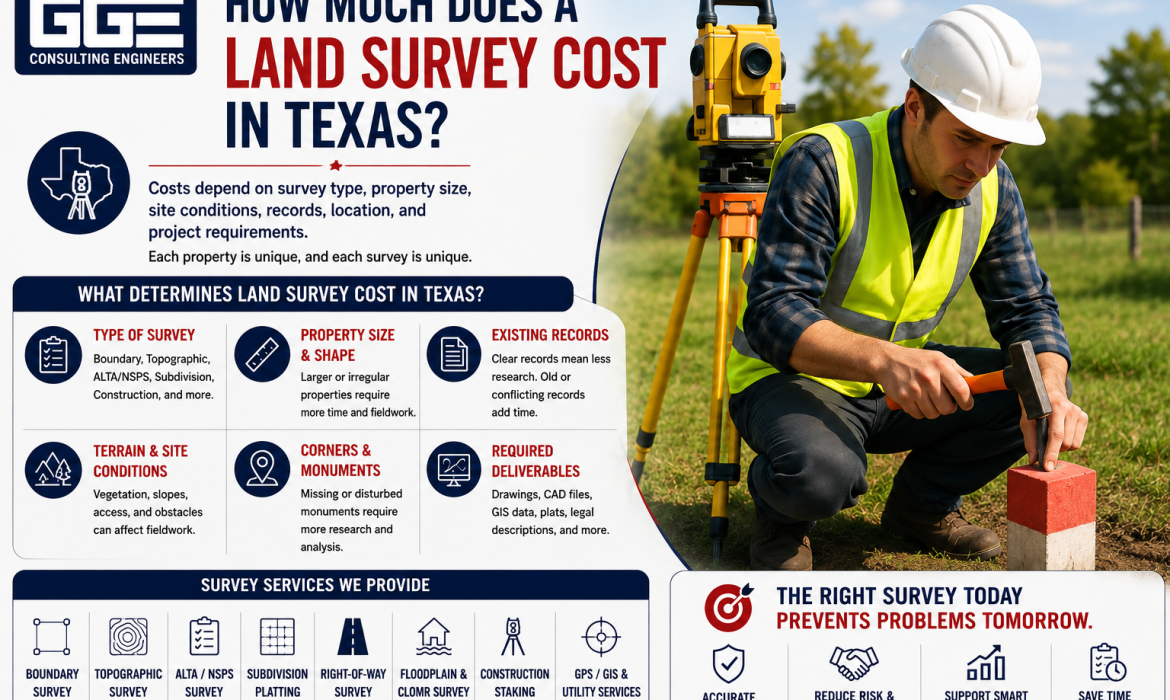
The land survey cost in Texas depends on the type of survey, property size, site conditions, records, location, and project requirements. GGE Consulting Engineers provides surveying services for property owners and development projects, helping clients determine the survey scope needed for their specific property.
There is no single price that applies to every Texas property. A boundary survey, topographic survey, ALTA/NSPS survey, subdivision survey, or construction survey can involve very different levels of fieldwork and documentation.
What Determines Land Survey Cost in Texas?
Surveying fees are generally based on the amount of professional research, fieldwork, data collection, processing, drafting, review, and documentation required.
The land survey cost in Texas can change significantly from one property to another because surveyors evaluate the actual conditions and requirements of each assignment.
1. Type of Survey
The type of survey is one of the most important factors affecting the overall scope.
A boundary survey focuses primarily on property lines and corners. A topographic survey provides information about elevations and existing physical features. An ALTA/NSPS Land Title Survey has a broader scope for commercial real estate transactions.
Other projects may require subdivision surveying, right-of-way surveying, floodplain surveying, construction staking, or other specialized services.
GGE Consulting Engineers lists boundary, topographic, ALTA/NSPS, subdivision platting, right-of-way, floodplain and CLOMR, construction staking, GPS/GIS, and utility-related surveying among its services.
2. Property Size and Shape
The size and configuration of a property can affect the amount of fieldwork required.
A small, regularly shaped parcel may be relatively straightforward to survey. A large or irregularly shaped tract may require more measurements, additional research, and more extensive fieldwork.
However, property size is only one factor. A smaller property with complicated boundaries or unclear records can require significant professional analysis.
3. Existing Property Records
Surveyors often review deeds, recorded plats, previous surveys, easements, rights-of-way, and other property documents.
Clear and consistent records can make the research process more straightforward. Older properties, conflicting legal descriptions, missing documents, or unclear boundary evidence can require additional research.
Providing available records before the survey begins can help the surveyor understand the property and determine the appropriate scope.
4. Terrain and Site Conditions
Physical conditions can influence fieldwork requirements.
Dense vegetation, wooded areas, steep slopes, fences, structures, water features, construction activity, and limited site access can make measurements more difficult.
A clear and accessible property may require less field effort than a site with obstacles or difficult terrain.
5. Property Corners and Monuments
Boundary surveys often involve locating existing monuments or other evidence of property corners.
When monuments are clearly identifiable and consistent with available records, the survey process may be more straightforward. Missing, disturbed, or conflicting monuments can require additional research and professional evaluation.
This is why the land survey cost in Texas should not be determined by acreage alone.
6. Required Deliverables
The final survey deliverables can also affect the scope.
Some projects may require a sealed survey drawing, while others may need CAD files, GIS data, digital terrain information, legal descriptions, plats, or other digital deliverables.
Before approving a proposal, confirm exactly what is included.
What Does a Boundary Survey Include?
A boundary survey is primarily focused on determining or retracing the legal limits of a property.
The surveyor may review property records and field evidence to identify property corners and boundaries. Depending on the agreed scope, the survey may also address easements, rights-of-way, encroachments, and other relevant conditions.
A boundary survey can be useful when:
- Buying or selling property
- Planning construction near property lines
- Investigating possible encroachments
- Locating property corners
- Preparing for development
- Preparing for subdivision
If the project also requires elevations, drainage information, contours, utilities, or other existing site conditions, a topographic survey may need to be included separately.
What Does a Topographic Survey Include?
A topographic survey focuses on the physical characteristics of a property.
Depending on the project scope, it may document:
- Existing elevations and contours
- Slopes and terrain
- Drainage features
- Structures and improvements
- Pavement and curbs
- Visible utility features
- Trees and vegetation
- Other relevant site features
Topographic information is often important for civil engineering and site development because existing conditions influence grading, drainage, utilities, roadway design, and building placement.
For development projects, collecting this information before detailed engineering begins can help the design team work from actual site conditions.
What Is an ALTA/NSPS Survey?
An ALTA/NSPS Land Title Survey is generally used for commercial real estate transactions where more comprehensive property and title-related information is required.
Unlike a basic boundary survey, an ALTA/NSPS survey is prepared according to specific national standards and can address property boundaries, improvements, easements, rights-of-way, access, and other applicable matters.
The required scope may also include additional Table A items requested by the client, lender, title company, or other authorized party.
Before ordering an ALTA/NSPS survey, confirm the requirements with the title company and lender when applicable.
How Property Location Affects Surveying Work
Property location can affect the logistics and scope of surveying work.
A property located within an established urban area may have different access, record, utility, and improvement conditions from a large rural tract.
Local requirements can also vary among municipalities, counties, and reviewing agencies. Development projects may need survey information that satisfies specific local requirements for subdivision, right-of-way, drainage, floodplain, or site development review.
This is one reason a local land surveying company in Texas can be useful when the project involves specific regional conditions or development requirements.
How to Compare a Land Surveying Company in Texas
Choosing a land surveying company in Texas should involve more than comparing the price shown on different proposals.
Instead, compare the actual scope and qualifications behind each proposal.
Check Professional Qualifications
Confirm that the surveying work will be performed under the appropriate Texas professional oversight.
GGE Consulting Engineers states that its surveying services are performed under Texas Registered Professional Land Surveyor oversight and provides surveying services for development and property-related projects.
Review Relevant Experience
Ask whether the company has experience with projects similar to yours.
A boundary survey for a residential property can have very different requirements from an ALTA/NSPS survey for a commercial transaction or a subdivision survey for a development project.
Compare the Scope
Make sure proposals address the same basic requirements.
Before hiring a land surveying company in Texas, ask whether the proposal includes:
- Record research
- Field measurements
- Property corner research
- Easement and right-of-way information
- Required survey standards
- Professional review and sealing
- CAD or digital files
- Other project-specific deliverables
- Expected completion schedule
- Additional services that may be required
A lower quote may not represent a lower overall cost if important services or deliverables are excluded.
How to Find a Surveyor Near Me
Searching for a surveyor near me can help identify firms serving your area, but proximity should not be the only consideration.
Look for a survey professional with relevant experience, appropriate Texas credentials, knowledge of local requirements, suitable surveying technology, and a clear understanding of your project.
When searching for a surveyor near me, it is useful to provide the property address, acreage, intended use, available property documents, and information about the type of survey you believe you need.
The surveyor can then determine whether that survey type is appropriate or whether additional information should be included.
Questions to Ask Before Hiring a Surveyor
Before authorizing surveying work, ask several practical questions.
- What type of survey does my project require?
- What information will be collected?
- Is record research included?
- Are property corners included?
- Will easements and rights-of-way be addressed?
- Are digital files included?
- Will the final survey be professionally reviewed and sealed?
- What information should I provide before fieldwork?
- How long will the survey process take?
- Could additional fieldwork become necessary?
These questions can help you understand the scope and avoid unexpected changes later.
How to Avoid Unnecessary Survey Costs
The best way to manage the land survey cost in Texas is to define the correct scope before fieldwork begins.
Start by explaining exactly how the survey will be used. A survey for a property purchase may have different requirements from one supporting construction or civil engineering design.
Provide the surveyor with existing deeds, plats, title information, previous surveys, easement documents, and site plans when available.
If the survey will support development, coordinate with the civil engineer before fieldwork. The engineering team may need specific information about elevations, drainage, utilities, structures, access, or other site conditions.
This coordination can help prevent the need for additional surveying later.
Common Mistakes That Can Increase Surveying Work
Ordering the Wrong Survey
A basic boundary survey may not satisfy a lender or title company’s requirements for a commercial transaction.
Assuming Every Survey Includes Topography
Boundary and topographic surveys serve different purposes. If the project needs elevations and existing-condition information, those requirements should be included in the scope.
Using an Outdated Survey
An older survey may not reflect current property conditions, improvements, access, easements, or development requirements.
Comparing Quotes Without Comparing Scope
Two proposals may appear different in price because they include different services or deliverables. Always compare the scope before making a decision.
Waiting Until Construction
Discovering missing survey information during construction can lead to additional fieldwork and potential project delays.
GGE Consulting Engineers and Land Surveying Services
GGE Consulting Engineers provides land surveying alongside civil and structural engineering services. Its published surveying capabilities include boundary surveys, topographic surveys, ALTA/NSPS Land Title Surveys, subdivision platting, right-of-way surveys, floodplain and CLOMR surveying, construction staking, GPS/GIS services, and utility-related surveying.
This range of services can support different stages of a development project, from establishing property boundaries and documenting existing conditions to supporting subdivision planning and construction layout.
GGE Consulting Engineers also coordinates surveying information with civil engineering services. This can be relevant when survey data will be used for grading, drainage, utilities, access, subdivision design, or other site development work.
Conclusion
The land survey cost in Texas depends on the type of survey and the complexity of the property and project. Boundary, topographic, ALTA/NSPS, subdivision, and construction surveys all have different purposes and requirements.
When selecting a land surveying company in Texas or searching for a surveyor near me, compare qualifications and scope rather than focusing only on the quoted fee. GGE Consulting Engineers provides surveying services that can coordinate with civil and structural engineering requirements for property and development projects. If you are unsure which survey your property requires, contact us to discuss your project and determine the appropriate survey scope.
Frequently Asked Questions
How much does a land survey cost in Texas?
The land survey cost in Texas varies according to survey type, property size, terrain, records, accessibility, required detail, and deliverables. The appropriate surveyor should review the property and project requirements before providing a project-specific proposal.
What is the biggest factor affecting survey cost?
The survey type and required scope are major factors. A boundary survey, topographic survey, ALTA/NSPS survey, subdivision survey, and construction survey involve different levels of work.
Is a boundary survey cheaper than a topographic survey?
A boundary survey may require less field and data collection than a topographic survey, depending on the project. However, actual fees depend on the property’s conditions and the required scope.
Does an ALTA/NSPS survey cost more than a boundary survey?
An ALTA/NSPS survey generally involves a broader scope and additional commercial transaction requirements. The actual fee depends on the property and the specific standards and items requested.
How do I choose a land surveying company in Texas?
When choosing a land surveying company in Texas, review its professional qualifications, experience with similar properties, understanding of local requirements, proposed scope, deliverables, and communication process.
Do I need a survey before developing property?
A survey is often an important part of development planning because it provides information about boundaries and existing site conditions. The exact type depends on the development project and applicable requirements.